| http://fos.bath.ac.uk/vas/papers/europIA98/ | rights of reproduction on request V.Bourdakis@bath.ac.uk |
Centre for Advanced Studies in Architecture, University of Bath, UK
Abstract: This paper draws on the experience of the author in creating large scale urban three dimensional computer models for historic, urban planning and conservation research as well as commercial purposes. Issues related to the creation of digital urban Virtual Environments (VEs) are briefly presented. The potentiality and future trends of utilising such VEs for research, education, entertainment and commerce is analysed and discussed. Shortcomings of existing methods and technologies are listed and ways forward suggested.
Over the past eight years a series of three-dimensional urban computer models have been developed in the Centre for Advanced Studies in Architecture (CASA) at the University of Bath. The main one, the Bath City historic centre was developed with the support of Bath City Council to be used as an urban planning tool. Following, Gloucester historic city centre computer model was constructed, as well as the London's West End the latter seen from a non-urban planning perspective. Finally, a traditional village of the Greek Aegean Island of Antiparos is currently been modelled for the Greek Ministry of Aegean, as part of a conservation plan and strategy pilot research programme. All computer models were constructed from aerial photographs using photogrammetry as the main source of information and are accurate to less than half a metre. Most of the models were constructed in order to assist the planning and development control process by providing a means by which planning proposals could be visualised and alternative schemes for a site compared.
Recent developments in the domains of Virtual Reality (VR) and the Internet triggered a series of research projects tackling the issues of interactivity, structure and management of large urban databases thus covering two of the three main aspects of VR as identified by Heim (1998); interaction and information intensity. Due to the particularities of the tasks aimed at, resources limitations and sheer size of the models involved, it was decided not to pursue the third aspect of immersiveness. As a result, the work in CASA is utilising large screen monitors or projection screens, input devices better than a plain keyboard and at least five to eight frames per second (fps) screen refresh rates. Such a setup can be engaging (but not immersive as defined by Slater et al, 1995) without the extra effort and complication of Head Mounted Displays (HMDs), position and direction tracking systems and refresh rates higher than thirty fps. Furthermore, as hardware improves, refresh rates will increase and eventually HMD will be fully compatible and useable with the digital urban models currently constructed.
As Heim (1998) explains, "VR is an emerging field of applied research" although in real life it is often used to signify non-realistic spaces and states of mind only possible to create/define on fully immersive set-ups. Regarding real life simulations and particularly urban space topography, bearing in mind the lack of immersiveness, the term Virtual Environments (VEs) coined by Media Labs (Massachusetts Institute of Technology) and University of North Carolina researchers in the early 1990ies is more appropriate and will be used throughout the paper.
World-wide, there have been many attempts in computer modelling urban spaces. The Virtual World Data Server Project currently under development by the UCLA Urban Simulation Team of the Dept. of Architecture and Urban Design (AUD) is one of the largest. In Berlin, the urban development and architecture unit of ART+COM has created the CyberCity Berlin and the Planwerk Berlin (a 3D masterplan for the city) employing new media in town planning drawing from their research on communication in city planning. A large scale project researching built environments, modelling, their development and management is carried out at the University College of London (UCL) Department of Geography. Approaching the topic from a historic viewpoint, ABACUS, Strathclyde University, have constructed a model of Edinburgh Old Town (Grant, 1993) and CASA has produced a model of mediaeval Bath, based in old maps and drawings of the city (Day, 1994). Finally, a number of companies have addressed the problem of 3D urban modelling for commercial applications, tourism and entertainment (Virtual Soma—the first virtual city on the Internet in August 1995, Bigbook, Virtual Derby, etc).
It is interesting to note that over the last few years, researchers, designers and decision-makers in general started realising the utility of Virtual Environments (VEs) as a communication tool. Furthermore, the emerging communication channels led to experiments on the commercial potential of urban VEs. Following, the issues of creating and identifying potential applications, shortcomings and the future of VEs will be discussed and analysed.
Computers have been used in architecture and in urban planning research for almost three decades (Mitchell, 1996), although adoption by practitioners has been slow mainly due to software and hardware limitations. Over the last decade, the expansion of high resolution input and output devices and the vast increase in raw computing power, led to the creation of efficient CAD packages and thus the construction of two-dimensional (2D) as well as three-dimensional (3D) computer models. Subsequently, urban 3D computer models were developed and a series of, well documented by now, problems tackled (Bourdakis, 1996). However, the introduction of interactivity and real time manipulation of urban computer models has proved to be a long and, to a great extent, ongoing process.
Compared to small scale VEs, urban scale ones involve working towards different aims, with a different approach and methodology, resulting in a completely different set of problems to be tackled. It is outside the scope of this paper to give insight on 3D computer urban modelling techniques. However, a brief introduction to urban VEs specific issues is necessary in order to appreciate the potential, complexity and problems related to their implementation.
There are a series of problems based on the intrinsic differences between VEs and Computer Aided Architectural Design (CAAD) environments. A generic problem is that buildings are modelled as a series of 2D faces positioned in 3D space, rather than solid 3D objects with intrinsic lifelike properties (enabling calculations on mass, centre of gravity, volume etc). This causes problems in terms of efficiency in the digital database format, as well as affecting the rendering performance of the urban VE. The lack of sufficient repetitiveness and symmetry (widely seen in other forms of VR scientific simulations/visualisations in the fields of chemical engineering, manufacturing etc) is a problem new and specific to urban VEs—particularly in historic city centres. Consequently, the resulting VEs can be extremely large in size (over 3 million triangles in Bath's case) creating even more problems in trying to achieve acceptable frame rates. Finally, integer calculations in most rendering VR engines, compromise geometric accuracy forcing reorganisation of drawing units and datum reference points.
Certain techniques have been modified from other fields, developed and employed to improve interaction with large scale urban VEs. Among them, the multiple level of detail structure of the datasets, QuadTrees for terrains, billboarding, visibility limiting and selective texturing etc. Structuring and layering vast amounts of information, editing and updating digital urban datasets, visualising and querying databases, navigation metaphors, are among the issues currently tackled by the author.
Application of urban VEs can be broadly classified under three main categories: design and planning, education and general research and finally commercial and entertainment. It should be noted that implementational directions vary greatly according to the application scope with certain tasks being clearly more suited to other media.
CASA built models demonstrate how and to what extend computers will be used in the near future by engineers as part of their everyday practice, creating, modifying and improving our cities online using centrally stored sharable databases. The aim is not to create yet another Geographical Information System (GIS) although GIS features can and will be incorporated. Using Internet compatible programming languages such as Java or ActiveX, urban VEs can replace a dedicated 2D based GIS system for certain applications (London’s West End, BigBook). It should be noted that due to the nature of the proposed use of such models, the low polygon count fully texture mapped model approach adopted by more commercial/advertising oriented projects (Virtual Soma, Virtual Derby etc.) is not feasible lacking severely in accuracy and detail. Multiple LODs as described earlier are vital for such VEs.
The Bath model has been used in a variety of ways since it was originally constructed. To date, development control has been its main use with a number of schemes being considered. These are normally at the instigation of the local authority who recommend that schemes are modelled in order to facilitate discussions during the design phase and for presentation to the planning committee. In addition to its use in development control, the model has also been used to widen the public debate on how the city should develop in the future.
In the rest of the world, there have been many attempts at employing computers in general and VEs in particular in the planning process. Examples range from photomontages and computer animations to fully hypermedia solutions (Shiffer, 1995) VR and interactive TV applications.
A couple of cases representative of the current and future trends are worth examining and presenting. In the Porta Susa Project, the urban area around a railway station in Turin Italy, a multilevel information system is created in order to enhance the design process (Caneparo, 1997). This system utilises different technologies in order to communicate ideas and concepts among the different groups involved. Therefore, asynchronous communication methods are used among the main team members (email, discussion groups, etc.) whereas shared VEs are used to enable public participation, development of ideas and feedback—the Internet been the backbone in both cases.
The future direction of urban planning application of VEs is clearly demonstrated by the Ijburg project in the Netherlands. On March 1997, inhabitants of Amsterdam voted on the construction of a new development; IJburg. In this context, a three dimensional representation of IJburg consisting of het IJ (a large lake close to Amsterdam) the surrounding small existing villages and the proposed development was modelled in the Virtual Reality Modelling Language (VRML) which is the Internet standard for interactive 3D models.
The model was broadcasted by the Dutch television several times during the three weeks prior to the referendum. While watching the live broadcast people were able to phone in, connect to the world, navigate through the model (using their phone keypad) and after a limited amount of time exploring the scheme, voice their opinion on the planned development. Opinions on the Ijburg scheme were imported in the VE as spheres (red for a "No" vote, green for a "Yes"), incorporating the recorded opinion of the caller. Subsequent callers could hear the previous visitor’s opinion whenever passing within certain distance from previous votes. To the author’s knowledge, this is the first example of implementing an interactive VE for urban planning at such scale although sadly it has not been publicised to the extent it should in order to trigger more research in this field of interactive TV with VEs.
Over the last decade, the potential of VEs as a teaching aid has been under investigation and as a result a range of curriculum material has been developed and evaluated. Research however has focused on primary and secondary education and as such, urban environments have not been employed. The closest to urban scale projects are investigation studies on spatial ability via "you are here" type of maps for pre-adolescents (Phileo, 1997) and the Cityspace project employing a virtual city environment built collaboratively by kids, educators, and media artists across the Internet. Young people are invited to share stories, pictures, sounds, and 3D models of their own creation, and to assemble them into navigable, three-dimensional city models.
Physical properties based analysis of urban space is a field that VEs can be of considerable benefit. The model of London’s West End is a typical example of research oriented modelling, where the level of detail and the amount of information included was carefully defined by the proposed use. British Telecom (BT) commissioned the model to CASA to be used for cellular telephones transmitter signal propagation experiments and as such, the main volumetric modelling was needed, together with primary facade and roof materials (to be used to assign reflective properties, etc). Roof geometry was important although facade detail (fenestration, cornices, etc) was disregarded.
Wayfinding and navigation (Charitos, 1997), albeit mostly tested using imaginary computer generated landscapes and urban spaces, are also important areas of urban VE application. Space analysis (Hillier, 1996), genetic algorithm research, investigating growth patterns (Batty et al, 1994) and generally visualising vast amounts of data and their internal structures are also tasks suited to VEs.
It is also important to point out research work investigating abstract data representations based on architectural notions of space such as Vector Zero carried out in co-operation with Silicon Graphics Inc (SGI) and CASA's own "Map of the Future" where the city becomes the front end facilitating navigation. Such works are vital sources of information on the future of urban VEs with particular focus on local authority strategies and policies deployment as they provide new ways of structuring and presenting data.
Finally, a more approachable area of VEs application is history education (Grove, 1996) and museum navigation/investigation. As Beardon and Worden (1997) explain, "there are alternative ways of interpreting the role of the museum which can also take advantage of the potential of multimedia technology". A simplified version of the Bath City VE has currently been proposed to link to the Building of Bath Museum database. As a result, visitors to the city (both actual/physical and virtual) will be able to examine the rich database of exhibits and artifacts to the museum via Internet based applications. The project was initially proposed due to the lack of space in the existing museum leading to many exhibits being stored and therefore non-accessible to the public. Computer terminals around the city (Tourist Information centre, Public library, schools, the museum itself, etc) could be used to search, learn and research on the city.
Implementing VEs and particularly urban ones in commercially viable fields is quite different to research and development. The implications and return of investment is one issue that is extremely difficult to assess and thus persuade the client. Furthermore, the technology needed, computer literacy level of the users, and incompatibility of the systems developed is quite high and thus causing problems. Consequently, the "wow" factor and the hi-tech issue is the main selling point of the technology at it currently stands. This is clearly demonstrated on the various urban VEs (in the loose sense of the term) created to enhance, improve virtual shopping mall applications which seem to expand is a fashion similar to that of shopping TV channels earlier in this decade. Typical examples are the urban models built by Planet9, a dozen US city centres, focusing on the prominent city landmarks (mainly skyscrapers, large office blocks and distinctive routes), which are pasted on a 2D map of the area. Detail is scarce, accuracy is questionable, conveying of information is not an issue, quality of the image is fairly poor and not appealing or even attracting attention, pausing questions on their financial and commercial viability.
In this lower end of the consumer market, panoramas have also been used, in most cases much more successfully in commercial applications as well as tourist, entertainment ones (Oxford city multi-nodal map, LivePictures panoramas of LA, etc). In the same scope, historic city centres multimedia tours have a more entertainment focus rather than commercial.
At a higher level of entertainment/recreational engagement lies the concept of virtual communities, inhabiting synthetic spaces often created by the users themselves, that develop and expand following methods similar to real communities. The pragmatic approach to this is the IRC and worldchat environments already created which lack greatly in terms of the visual aspect. In many cases, textual interfaces are used to build a virtual experience (Community Space, ColonyCity by Black Sun Interactive, etc). On the other extreme is the Metaverse as proposed by N.Stephenson in his novel SnowCrash (1993) described as a place better than reality where people simply "retreat" to experience a better world.
During 1995, a different version of the London's West End model (based on the same source data) was developed in CASA—as a database front end to navigating and mapping information on the city. As part of the experiment the Map of the Future was constructed, linking freely available WWW resources to the 3D model, creating a hyperlinked, user upgradeable, city database (Bourdakis, 1996) utilising the Virtual Reality Modelling Language (VRML). Resources related to tourists and visitors in general (accommodation, entertainment, services, etc) were linked to the digital model. The idea being that over the next decade, most city related information (as more or less every type of information) will be available on computers and, judging from the recent expansion of the Internet (Negroponte, 1995), available on the WWW in one form or another. Urban models could be used to organise such information and work as 3D fully interactive maps/indices of our cities/lives.
Concluding with the potential uses of urban VEs it should be stressed that in many of the examples discussed above, the notion of a city space is used fairly loosely, denoting the various ways people perceive cities. It may vary greatly from one building complex, to a High Street, a neighbourhood or indeed a whole city (very rarely, if ever at all). This should be kept in mind especially when examining work carried out—very often it is not what it claims to be.
As mentioned in the previous section, VEs are not always applied / utilised to their full potential, by either commercially or scientifically. In the following, the issues of suitability and applicability of VEs compared to the other means will be analysed and presented. Other means can be broadly classified as: 2D such as drawings, photographs and montages, 2D animated/interactive such as panoramas, video and finally 3D scale models, etc.
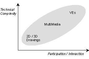
The key issue is the balance between effort and results as seen in Figure 1. Minimum level of participation/interaction reflects to relatively low technical complexity resulting in simple 2D maps, drawings and sketches. Half way up the level of complexity are the multimedia presentations achieved using animations, 2D and 3D drawings etc. The utmost stage of participation/interaction is covered by Virtual Environments (V.E.s) that, although not necessarily immersive, to present us the highest technical difficulties.
Figure: Interaction versus technical complexity
Starting from the low level of interactivity and effort, photomontages have been used extensively. A higher effort solution leads to multimedia presentations where animations, renderings, photomontages, video footage etc. are inter-linked. Hypermedia links improve the effectiveness of the medium, by enabling the user to move between different references and sources of information as well as different presentation media (Hall 1996). Vital information is not presented in spreadsheet formats that a lay person lacks the expertise to comprehend, but in a visual form. Navigation is carried out using visual or "gestural" human computer interaction tools instead of verbal or "command driven" ones (Shiffer, 1995).
A solution is to use edited video-photomontage 360degree photorealistic panoramas for public participation exercises and keep the abstract level of VEs to an acceptable level of quality and accuracy to be used by trained professionals.
Urban VEs can be used at two levels of complexity/engagement; low level, as a presentation, evaluation and educational tool as well as a planning support analytical tool, more advanced, real-time editing tool to be used by especially trained professionals. In the author’s opinion, the role of VR technologies is not to imitate reality but to aid in communicating ideas, designs, teaching, etc. in situations where the real environment is unavailable, unreachable or generally inaccessible. The level of abstraction used must balance the projected use of the model and not overcomplicate the VE unless there is a clear and justifiable reason to do so. Therefore, a multi level of resolution approach is vital.
Furthermore, the effort involved in achieving high level of 3is (Heim, 1998) is disproportionate to the feedback/return of investment. Photomontaged panoramas will be much more appropriate, less resource hungry, more user-friendly, more foolproof, less prone to crashing and disconcerting disorienting experiences than interactive VEs.
As a way of concluding, a few thoughts on where VEs can/should/cannot be used now and in the future follow.
Urban planning schemes in sensitive areas that public participation should be encouraged and facilitated. Drawings and carefully selected renderings are often misleading all but the most experienced professionals. Information visualisation can be achieved easier since manipulating and rearranging information, using graphic symbols, can be more easily understood.
Internet based (as well as CDROM standalone) applications teaching history as well as tourism geared ones can take advantages of existing technology. The higher degree of interaction achieved (compared to maps and videotapes) facilitates learning, "…making learning more interesting and fun" (Pantelidis, 1996) while travel costs and logistics makes it an attractive alternative.
Commercial applications attempting to impress the public, without any substantial underlying reason for their existence as VEs. More often than not, VEs are too expensive to justify using them producing very poor results when implemented incompletely. Java interactive applets and photorealistic panoramas are much more appropriate means to convey information. Public access points with no guidance and support since VEs are still difficult to navigate and comprehend for the non-technically minded and computer experienced; interface design is a very important issue. It is hoped that this will change soon.
Advances in hardware as well as software (although the main concern at the moment is hardware capabilities in terms of data bandwidth, processors and graphics subsystems performance) should see us into more cost effective solutions to distance learning material, remote participation etc. This is especially true since peoples' work pattern and companies' structure change rapidly. Furthermore, shared urban VEs will take off, especially in planning evaluation exercises with various experts in the field "joining in" to voice their opinions.
Ashworth, G.J. (1997) Conservation as Preservation or as Heritage; Two Paradigms and Two Answers. In: Built Environment, Vol 23.2, pp.92-102.
Batty, M. and Longley, P. (1994) Fractal Cities: A Geometry of Form and Function, Academic Press, London and San Diego.
Beardon, C. and Worden, S. (1997) The Virtual Curator: Multimedia Technologies and the Roles of Museums In: Contextual Media E.Barrett and M.Redmond (eds), MIT Press.
Bourdakis, V. (1996) From CAAD to VRML: London Case Study, The 3rd UK VRSIG Conference. Full Paper Proceedings, De Montfort University.
Bourdakis, V. and Day, A. (1997) The VRML Model of the City of Bath, Proceedings of the Sixth International EuropIA Conference, europia Productions.
Broadbent, G. (1990) Emerging concepts in urban space design. Van Nostrand Reinhold.
Byrne, C. (1996). Water on Tap: The Use of Virtual Reality as an Educational Tool. Doctoral Dissertation. <URL: http://www.hitl.washington.edu/publications/dissertations/Byrne/>
Canapero, L. (1997) Shared Information System for Urban and Architectural Design, Proceedings of the Sixth International EuropIA Conference, europia Productions.
Day, A (1994) From Map to Model: the Development of an Urban Information System Design Studies, Vol 15, No.3.
Grant, P.M. (1993) Urban GIS – the application of information technologies to urban management. In: Informing Technologies for construction, civil engineering and transport. Powell, J.A. and Day, R. (eds), Brunel University, Uxbridge.
Grove, J. (1996) VR and History - Some Findings and Thoughts. In: VR In Schools, Vol.2, No.1.
Hall, A.C (1996) Design Control; Towards a new approach Butterworth Architecture, Oxford.
Heim, M. (1998) Virtual Realism Oxford University Press.
Hillier, B. (1996) Space is the machine; a configurational theory of architecture Cambridge University Press.
Liggett, R., Friedman, S., and Jepson, W. (1995) Interactive Design/Decision Making in a Virtual Urban World: Visual Simulation and GIS. Proceedings of the Fifteenth Annual ESRI User Conference. Palm Springs, CA.
Mitchell, W.J. (1996) City of Bits. MIT Press.
Jepson, W., Liggett, R. and Friedman, S. (1996) Virtual Modeling of Urban Environments Presence 5(1).
Pantelides, V. (1996) Suggestions on When to Use and When Not to Use Virtual Reality in Education. In: VR in Schools, Vol.1, No1.
Negroponte, N. (1995) Being Digital. Hodder and Stoughton, London.
Perraton, Jean (1978) Evaluation as part of the planning process. Land Use and Built Form Studies Working Paper No.33. University of Cambridge.
Philleo, (1997) The Effect of Desktop VR on the Spatial Ability of Pre-Adolescents In: VR in the School Vol.2, No.4, March 97
Phillips, P.C. (1996) Portraying the City. In: City Speculations P.C. Phillips (ed) Princeton Academic Press.
Shiffer, M.J. (1995) Multimedia Representational Aids in Urban Planning Support Systems In: Understanding Images; Finding Meaning in Digital Imagery F.T. Marchese (ed) Telos, Springer-Verlag, New York.
Slater, M. and Wilbur, S. (1995) Through the Looking Glass World of Presence: A Framework for Immersive Virtual Environments In: Framework for Immersive Virtual Environments FIVE’95 Esprit Working Group 9122, QMW University London.
Stephenson, N. (1993) Snowcrash. ROC Penguin Books