| http://fos.bath.ac.uk/vas/papers/CAAD-TNDC/ | rights of reproduction on request V.Bourdakis@bath.ac.uk |
VIRTUAL REALITY: A COMMUNICATION TOOL FOR URBAN PLANNING
Centre for Advanced Studies in Architecture, University of Bath, U.K.
Abstract:
During the past six years a series of three-dimensional urban computer models have been developed in the Centre for Advanced Studies in Architecture (CASA) at the University of Bath. Models were constructed in order to assist in making the planning and development control process more flexible by providing a means by which planning proposals could be visualised and alternative schemes for a site compared. Developments in the domains of Virtual Reality (VR) and the Internet triggered a series of research projects carried out in CASA tackling the issues of interactivity, structuring and management of large urban databases. Over the last few years, designers started utilising some of the potential of VR as a communication tool both within the design team as well as with clients. In this paper, the suitability of VR as an urban planning communication tool is presented, analysed and assessed. The various potential communication channels (eg. local authorities versus planners and the public, architects/engineers versus clients as well as all three parties together) are discussed. Finally, recent examples around the world are assessed and concerns on the future of urban planning are expressed.
Orientation
Computers have been used in architecture and in urban planning research for almost three decades (Mitchell, 1996), although adoption by practitioners has been slow mainly due to software and hardware limitations. Over the last decade, the expansion of high resolution input and output devices and the vast increase in raw computing power, led to the creation of efficient CAD packages and thus the construction of two-dimensional (2D) as well as three-dimensional (3D) computer models. Subsequently, urban 3D computer models were developed and a series of, well documented by now, problems tackled (Bourdakis, 1996 and Bourdakis et al, 1997). However, the introduction of interactivity and real time manipulation of urban CAD models has proved to be a long and, to a great extent, ongoing process.
The Centre for Advanced Studies in Architecture (CASA) has been involved in 3D computer modelling for the last six years. In 1991 CASA received a grant to construct a 3D computer model of the city of Bath. Bath City Council supported the project and since its completion city planners have used the model to test the visual impact of a number of proposed developments in the city. The model was constructed from aerial photographs using photogrammetry, is accurate to less than half a metre and covers the whole historic city centre, an approximate area of 2.5x2.0 km (Bourdakis et al, 1997). During the year 1995 and using similar construction techniques, the core of London’s West End covering 1.0X0.5km was also modelled followed by Gloucester City centre in 1996 (covering an area of 750X500metres).
Following the expansion of the Internet, the World Wide Web (WWW) and current trends in the industry, VR versions of the Bath and London models have been used on various research projects, employing Virtual Reality Modelling Language (VRML) as well as custom made non-immersive VR applications (Day et al, 1996). The Bath database is, to the author’s knowledge, the largest and most detailed one produced as yet. Worldwide, there have been many attempts in computer modelling urban spaces at city scale. The UCLA Urban Simulation Team of the Dept. of Architecture and Urban Design (AUD), following the design of the Urban Simulator (Liggett et al, 1995), is currently building a model of the entire Los Angeles basin. Virtual L.A. covers an area in excess of 10000 square miles as part of "The Virtual World Data Server Project". This ambitious program, once completed, is intended to be used for urban simulations as well as 3D interactive visualisations of various data forms. In Berlin, the urban development and architecture unit of ART+COM has created the CyberCity Berlin and the Planwerk Berlin (a 3D masterplan for the city) employing new media in town planning drawing from their research on communication in city planning. In the UK, one of the first comprehensive urban models was that of Glasgow constructed by ABACUS at the Strathclyde University in the mid 80ies. Recently, the University College of London (UCL) Department of Geography has embarked in a large-scale project researching on ways of producing built environments using VR systems focusing on London. Approaching the topic from a historic viewpoint, ABACUS have subsequently constructed a model of Edinburgh Old Town (Grant, 1993) and CASA has produced a model of mediaeval Bath, based in old maps and drawings of the city (Day, 1994). Finally, a number of companies have addressed the problem of 3D urban modelling for commercial applications, tourism and entertainment (Virtual Soma—the first virtual city on the Internet in August 1995, Bigbook, Virtual Derby, etc).
It is also important to point out research work investigating abstract data representations based on architectural notions of space such as Vector Zero carried out in co-operation with Silicon Graphics Inc (SGI). Such works are vital sources of information on the future of VR in urban planning with particular focus on local authority strategies and policies deployment since they provide new ways of structuring and presenting information.
In this paper, an account of communications in urban planning is given followed by an analysis of the role of VR in planning, its advantages and disadvantages. Finally conclusions are drawn on the applicability of VR systems in urban planning and their future.
Communications in urban planning
Urban planning is a complex process encompassing aspects of social, economic, physical and spatial significance. These aspects are not independent, interacting with each other within the urban system (Perraton, 1978) therefore the decision-making process depends on a dialectic relation between them all. As such, communication among these various aspects is central to urban planning. One can distinguish at least four distinct groups involved in the whole process, each having different and often conflicting expectations, background and most importantly foci. More specifically, the planners working for the local authorities, the architects/planners working for clients, the clients themselves and the general public (Hall, 1996). Furthermore, different stages of the design and evaluation process demand varying skills and abilities, thus making the urban planning process even more complicated and difficult.
Hall (1996) highlights the communication difficulties between planning authorities and designers as well as the deeper underlying problems of design policy deficiencies that eventually lead to uncertainty and lack of consistency. This is an inevitable outcome of an informal, to a large extend, planning culture passed on by word of mouth rather than carefully and clearly established policies and frameworks. Furthermore, there is a lack of consistency on the levels of detail employed by planning authorities in presenting and documenting their policies and strategies to both professionals and the public. There is clearly a series of communication problems in this field and it has been advocated that computers can offer satisfactory solutions (Day et al, 1995 and Hall, 1996).
It is therefore vital that any planning process should leave space for discussions between the planners and both local authorities and the public. An important issue for facilitating this communication process is to promote data presentation that is informative, accessible and able to successfully present complex interactions, phenomena and underlying expert analyses to professionals as well as lay people. Similar techniques have been employed successfully over the last few years in presentation graphics for election results, major sporting event results, etc.
Concluding, local authorities are increasingly becoming aware on the possibilities available to them when embracing new technologies and accept the communication problems they are facing—from CASA’s experience, the Bath and Gloucester local authorities directly or indirectly commissioned their respective computer models. The former with the vision of being used as an urban planning tool the latter as part of a Millennium fund bid. Of course everything is not as simple as it seems and new technology can be a hindrance rather than a valuable tool facilitating an effective communicative process. The expectations of participants and interested bodies, the brief and the attainable goals play a major role in the overall outcome. Experience in the field shows that there is an increased trend of overestimating the capabilities resulting in unsatisfied parties and solutions.
Employing VR at an urban scale
Virtual Reality has been defined in many different ways over the years. Concepts such as interactivity, immersion, sensory input etc have been used extensively for characterising its nature (Slater et al, 1995). In CASA, bearing in mind the particularities of urban planning and resources limitations, a VR system comprises of a large screen display, any input device better than a keyboard and at least five to eight frames per second (fps) screen refresh rates. Such a setup can be engaging without the extra effort and complication of Head Mounted Displays (HMDs), position and direction tracking systems and thirty plus fps. Furthermore, as hardware improves, refresh rates will increase and eventually HMD will be fully compatible and useable with CASA developed models. The important issues currently tackled in CASA are these of structuring and layering vast amounts of information, capabilities of visualising and querying databases, navigation metaphors, etc. It should be stressed that the extremely large sizes of models (over 3 million triangles in Bath’s case) and the lack of sufficient repetition are problems new to VR in urban planning that previous applications (chemical engineering, manufacturing, education) did not suffer from.
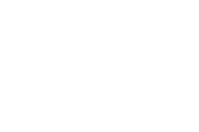
As new technology becomes more affordable and professionals more familiar with its potential, urban planning tools will develop to eventually fully interactive, multimedia and possibly VR solutions. The key issue is the balance between effort and results as seen in Figure 1. Minimum level of participation/interaction reflects to relatively low technical complexity resulting in simple 2D maps, drawings and sketches. Half way up the level of complexity are the multimedia presentations achieved using animations, 2D and 3D drawings etc. The utmost stage of participation/interaction is covered by Virtual Environments (V.E.s) that, although not necessarily immersive, present the highest technical difficulties.
Figure 1. Interaction versus technical complexity
VR Urban models can be used at two levels of complexity/engagement; low level, as a presentation and evaluation tool as well as a planning support analytical tool, more advanced, real-time editing tool to be used by especially trained professionals. In the author’s opinion, the role of VR is not to imitate reality but to aid in communicating ideas, designs, teaching, etc. in situations where the real environment is unavailable, unreachable or generally inaccessible. Therefore, the models created in CASA will always look and feel computer generated. The level of abstraction used balances with the projected use of the model and is not overcomplicating the VE unless there is a clear and justifiable reason to do so—careful use of textures on key buildings and low resolution photographs of the shop-front area are only used. Therefore, a multi level of resolution approach is vital.
CASA built models demonstrate how and to what extend computers will be used in the near future by engineers as part of their everyday practice, creating, modifying and improving our cities online using centrally stored sharable databases. The aim is not to create yet another Geographical Information System (GIS) although GIS features can and will be incorporated. Using Internet compatible programming languages such as Java, Cobra or ActiveX, VR urban models can replace a dedicated 2D based GIS system for certain applications (London’s West End, BigBook). It should be noted that due to the nature of the proposed use of such models, the low polygon count fully texture mapped model approach adopted by more commercial/advertising oriented projects (Virtual Soma, Virtual Derby etc.) is not feasible lacking severely in accuracy and detail. Ideally models containing multiple levels of detail are needed to support the range of tasks at hand. It is outside the scope of this paper to give insight on 3D computer urban models, creation techniques and potential uses; for a more detailed analysis see Day et al (1996).
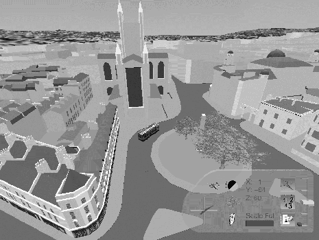
Figure 2. View of the Bath model in VRML
The Bath model (Figure 2) has been used in a variety of ways since it was originally constructed. To date, development control has been its main use with a number of schemes being considered. These are normally at the instigation of the local authority who recommend that schemes are modelled in order to facilitate discussions during the design phase and for presentation to the planning committee. In addition to its use in development control, the model has also been used to widen the public debate on how the city should develop in the future. Until recently, this was implemented using photomontages and computer animations. Over the last three years, research tools (Polytrim from the Centre for Landscape Research at the University of Toronto, Danahy et al, 1995) and more recently commercial (Inventor and VRML) have been used for most proposal investigation work. However, local authorities limited resources mean that for planning committee meetings we still have to rely on photomontages and still images. Gloucester’s city centre model (Figure 3) completed in early 1997, is currently being used for planning control similarly to the Bath model.
The model of London’s West End (Figure 4) is of lower level of detail and was initially used for cellular telephones transmitter signal propagation experiments by British Telecom (BT). CASA has been using it as a database front end to navigating and mapping information on the city thus creating the Map of the Future published on the WWW since October 1995. As part of the experiment, freely available WWW resources have been linked to the 3D model, creating a hyperlinked, user upgradeable, city database (Bourdakis, 1996). Visitor specific aids (accommodation, entertainment, services, etc) as well as some engineering focused information (underground servicing channels etc) are currently linked to this model. The idea being that over the next decade, most city related information (as more or less every type of information) will be available on computers and, judging from the expansion of the internet over the last decade (Negroponte, 1995), available on the WWW in one form or another. Urban models should be used to organise such information and work as 3D fully interactive maps/indices of our cities/lives.
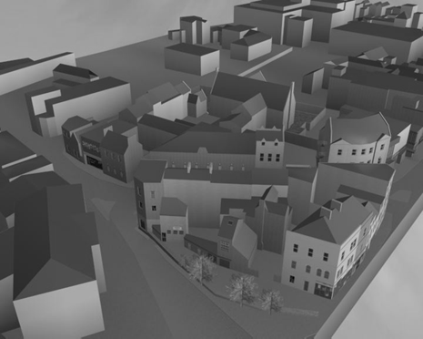
Figure 3. Computer Rendering of the Gloucester model
In the rest of the world, there have been many attempts at employing computers in general and VR in particular in the planning process. Examples range from photomontages and computer animations to fully hypermedia solutions (Shiffer, 1995) VR and interactive TV applications.
Starting from the low level of interactivity and effort, photomontages have been used extensively. A higher effort solution leads to multimedia presentations where animations, renderings, photomontages, video footage etc. are inter-linked. Hypermedia links improve the effectiveness of the medium, by enabling the user to move between different references and sources of information as well as different presentation media (Hall 1996). Vital information is not presented in spreadsheet formats that a lay person lacks the expertise to comprehend, but in a visual form. Navigation is carried out using visual or "gestural" human computer interaction tools instead of verbal or "command driven" ones (Shiffer, 1995).
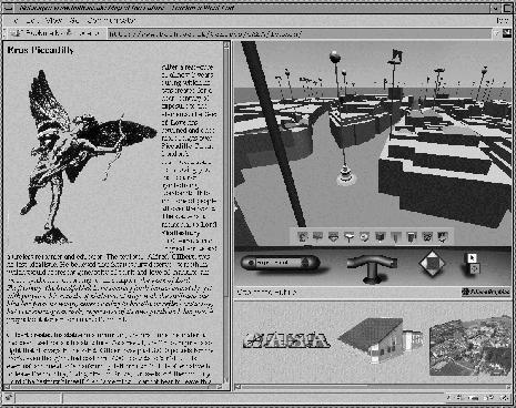
Figure 4. London’s West End on the WWW
A case worth mentioning, as it clearly demonstrates the direction that future urban planning tools are leading, is that of IJburg in the Netherlands. On March 1997, inhabitants of Amsterdam voted on the construction of a new development; IJburg. In this context a three dimensional representation of IJburg was modelled in the Internet language VRML. The IJburg computer model consists of het IJ (a big lake) the small existing villages of Durgerdam, Diemen, Muiden, etc around it and the proposed development in the middle of the lake.
The model was broadcasted by the Dutch television several times during the three weeks prior to the referendum. While watching the broadcast people were able to dial a special telephone number, connect to the world (one person at a time), navigate through the model and voice their opinion on the planned development. Navigation was done using their telephone keypad—key to movement mapping ergonomically derived from the position of the keys on the phone set (pressing 2 for going forward, 8 for backward, 4 for turning left, 6 for turning right, etc.). Every person watching at the time of the broadcast would follow this happening. After ninety seconds, the callers were asked if they would like to vote for or against the new development of IJburg. When voting 'yes' a green sphere was placed right at the place in the model where the person was, when voting 'no' a red sphere was placed. Following the voting, visitors could leave their opinion on IJburg. Their voice was then linked to their voting sphere and whenever a following caller/visitor would pass by this sphere they would hear the previous visitor’s opinion. To the author’s knowledge, this is the first such example of implementing an interactive VE for urban planning at such scale. Undoubtedly more will follow.
Advantages of VR based tools
As it often happens when a new technology is introduced, VR has been viewed as panacea for various research fields that seek to manipulate information visually. It has been applied and argued as being the ultimate solution to problems ranging from training and teaching to entertainment, information management and data mapping, medical and chemical visualisation, etc. Although not entirely true in all fields, VR, when used carefully and sensibly, seems to facilitate research and practice in urban planning. However, care should be taken and thus further research is needed on the implications of its use in different stages of the negotiation/design process.
Traditional planning techniques are time consuming, focusing on experts judgement and often addressing superficial rather than fundamental issues due to lack of resources and the poor methods used in conveying the relevant information. Rendered images and more recently photomontages and even computer animations of proposed schemes are bound to the views submitted by the designers (Hall, 1996). Architects have a reputation for submitting non-realistic perspectives, omitting parts of schemes that are not fully designed and even hiding areas of schemes behind carefully placed trees and other "features". Such communication deficiencies can subsequently lead to unsatisfactory buildings and heated post construction debates.
On the contrary, VR facilitates freedom of movement within the scheme and the simulation of movement at ground level minimises the dangers and misconceptions of bird’s eye view perspectives that scale models and computer generated images very often suffer from. Presentation and comparison of alternative schemes is simplified and building elements can be selected and investigated in greater detail if needed. Most importantly, VR enhances communication channels, offering immediate feedback by limiting the need for the design - export - render cycle found on conventional approaches.
The ability to interactively visualise projects in context and the limited degree of visual manipulation the proposing team can enforce are also important advantages of a VR approach to planning. Additionally, the design, evaluation circle can be significantly shortened since digital information is much more easily manipulated, edited and presented. The lack of scale of digital data and inherent support for multilevel representations make 3D computer models in general and VR ones in particular, as suitable for a loft conversion as for a new shopping centre or a large scale housing development.
Utilising VR, planners can map on the site and its surroundings census data, land use and behavioural diagrams, vehicle, climate and pollution simulations and other data enhancing experts assessment and most importantly reducing the need for site familiarity. Superimposing historical information on the existing urban structure enables import of local information/feedback from relevant parties. It is believed that such an informational environment can greatly enhance the planning process both within a multidisciplinary design team and during the evaluation of proposals.
One of the main arguments for VR is that similarly to other representational aids such as multimedia, it facilitates the illustration of changes whilst minimising the cognitive load to the recipient (Hall, 1996). Bearing in mind that public participation in urban planning usually ends in the local scale focusing on the detailed level of the proposals rather than the abstract initial stages and goals (Levin, 1971) it can be argued that VR enables more substantial public participation, making information more accessible and comprehensible.
Risks in adopting VR for urban planning
This paper does not advocate that the planning process should be exclusively carried out in a computer-based environment. Indeed, the lack of suitable tools makes such a proposition pointless (Cambell et al, 1994). What is advocated is that VR can be a valuable planning tool if used within the limits of available technology and software. Following, a series of limitations and problems linked to the use of VR in urban scale projects are presented.
What VR in urban planning cannot yet achieve:
A Collaborative VE: There is a need to carefully establishing wealthy processes before embarking to a more advanced and complex stage. Successful collaborative VEs have been mainly developed for computer-related tasks as well as offshore plants and mechanical engineering design. They are feasible but the software currently available is not suitable for design and planning at an urban scale. Undoubtedly, new solutions will appear soon, but caution should be exercised to avoid creating more problems instead of solving current ones.
Immersive VE have proved in various occasions to be quite problematic—a lot of resources are needed to make them work, limiting the usefulness of the overall project. It is becoming increasingly feasible but as Byrne (1996) argues, interactivity is still the significant factor, immersiveness is often disorienting, problematic and from his experiments not significant. Training, virtual world design, aesthetics, level of detail, assessment and low level of hardware resolution are among the possible reasons for immersion's lack of significance. However, a carefully designed interactive VE can be much more practical and useful. Furthermore, planning committee meetings are not feasible in an "immersive" VE; the person to person communication, gestures etc that are so important in the "real" meeting cannot be simulated successfully. Nevertheless, large screen displays similar to the various Reality Centres, built by SGI, are ideal—if not outside the budget of even the wealthiest city council. Resources, as mentioned earlier, is a factor of paramount importance and mainly responsible for the fact that there are practically no successful applications of highly detailed VR in city models.
Questions on the implications of employing VR:
Who controls the overall balance in a multidisciplinary team?
As in all multidisciplinary evaluation processes, care must be taken in assigning relative importance co-efficient factors to each participating group. In this particular occasion such a task would be quite difficult. Citizens’ votes and opinions could be either used as a trend indicator and subsequently only considered in the final meetings as recommendations, or could play a more substantial role in decision making. Bearing in mind the high degree of public participation in UK planning committees, the latter would be more appropriate.
Media’s effect on decision making?
Drawing from the IJburg example, it seems that the media are becoming more influential on decision making. It is interesting to examine the participation pattern in community decision making over the last 25 centuries starting from the Athenian city-state democracy of the 5th century BC where all citizens would meet and vote in Pnyka on all matters, to the expansion of societies where such an act was not desirable as well as impractical eventually leading to totalitarian ruling. Following the industrial revolution, media (mainly the press and radio) have played an important role in informing and educating the public. Nowadays, with the vast majority of the population using radios and TVs, it is becoming possible to have a much higher degree of participation in decision making not only for government elections but for individual cases that referendums would be difficult and too resource intensive processes. The critical questions is, can society handle such actions and are they really helpful?
What do Professionals think and feel about this emerging situation?
The introduction of computers was the first step, now that interactive planning tools are becoming feasible and even available (although still mainly at a research level), the natural development is to embark into VR design tools that will eventually be used by everyone and not only the building professionals. Such a development could potentially minimise the input from professionals in the design/planning process as well as causing a series of other problems the most important being the reluctance of professionals to use the new technology and computers in their everyday work. A similar situation was observed with the introduction of walkthrough animation tools on various CAAD software over the last few years. Many architects detest using them since such tools are likely to cause more debates, leading to alterations on the initial design, recalculations and potentially loss of revenue. However, such tools can also lead to more satisfied clients as well as being a strong marketing tool, making the whole issue much more delicate.
This is the author’s main concern on the fully editable, immersive (or not) design tools that have been discussed but not yet materialised commercially. The professional may, to a certain degree, be downgraded to becoming the "operator" of the software and the design process may become much more laborious, with many more arguments and "ideas" to be analysed and discussed. Furthermore, using the existing design methodologies and CAAD conventions, fully 3D design is a serious and awkward process; even more a VR based one, where the designer is not alone in investigating solutions and importing/testing them on a computer screen / headset / projection screen. It may be that the urban planning profession needs reassessment and in the future would have a more supervisory role rather than a mainly active participatory one (although the author is not looking forward to such a development).
The future of urban planning tools
Future developments in both hardware and software will alter the way planning is seen and practised throughout the world. Starting with, the management of shared resources will become an issue; with urban databases created by different teams, constant updating, cross-relation and synchronisation is vital. Furthermore, the replication of data collection and modelling should be minimised and sharing of resources encouraged. Varying levels of data resolution and overlaying of different types of information demands careful centralised organisation of all the resources available for each area/city. Finally, compatibility of the urban VR computer models built in different areas of the country or even different countries will be an issue. Standards of VR urban model creation should be developed and employed.
City councils or possibly especially formed speculative bureau could be responsible for maintaining, storing and handling such centralised databases. Issues of copyrights and cost of use for such datasets will need to be addressed. Furthermore, since both the design and planning process are full of conventions, most of them relating to the paper based information distribution to the various construction related professions, such conventions will have to be re-assessed and possibly modified or abolished in a VR environment (staircases arrows, opening information, confusing projection lines). As a result, the issue of supporting professionals with suitable VR, or desktop, design and presentation tools and relevant guidelines will have to be addressed. Consequently, both professionals and the general public will have access to parts of the urban VR models to prepare their proposals that will then be presented in 3-4 sided meetings.
Subsequently, the planning evaluation process will have to be reconsidered, experts could be called from around the globe to participate on "virtual" meetings where all the information needed will be available on computer/TV screens and site familiarity will be of minor importance. Some special type of autonomous agents (Negroponte, 1995) may well be providing the type of information one would expect to gather by spending days if not weeks wondering in the streets of the city interacting with locals, learning from them the history, trends, current affairs/problems facing etc. In all these developments the Internet, being the most suitable distribution medium, will be a key issue to improving communication.
Conclusions
Employing VR systems in urban planning, the evaluation process changes drastically mainly in terms of committee structure, background and participation level. As a result, evaluation becomes an information rich process that imposes practically no limits on the qualifications of the committee members—helping both the expert and the novice committee members. The focus of the paper has been on the evaluation stage only—the tools available for the design process are a quite different issue and needs to be considered separately.
Two dimensional tools and photomontages are performing well on certain tasks—photorealistic stills, colour schemes studies, high level of detail decision making, etc. VR tools have a leading edge when the planning of spaces is assessed. Immersive VR systems may be more suitable for such tasks since it is easier to evaluate a 3D space while immersed in a stereoscopic model with a HMD compared to "experiencing it" via subjective 2D artist impressions or even 2D computer displays. On the negative side, generally the visual tools of VR are poor in comparison but there are many occasions that realism is not really needed. Shadowing and volumes, visual obstructions are cases where a fairly low-level volumentric model is sufficient. However, it should be noted that the high level of detail easily obtained following a non VR approach gives scale, quality and familiarity with the site that is extremely difficult to maintain in a VR urban model.
Concluding, the improved communications in our disposal led to a few broader questions. Are we close to giving too much control to the public in deciding about the future of the built environment? Does this mean that the urban planning is heading towards a 5th Century BC Athenian democracy scenario where every citizen had the right to comment and vote? Is it something needed and indeed wanted? Finally, what will the role of architects and planners be in the future? Are they going to be needed, or will the cities of the future be decided on phone voting sessions based on an series of interactive TV programmes were the public will vote for the facade, type of windows or roof shape of their new town hall? It all is an issue of balance of opinions as well as socio-political decision making.
References
Benford, S., Greenhalgh, C., Snowdon and D., Bullock, A. (1997): Staging a Public Poetry Performance in a Collaborative Virtual Environment. The 5th European Conference on Computer Supported Cooperative Work (ECSCW'97), 7-11 September 1997, Lancaster, UK.
Bourdakis, V. (1996) From CAAD to VRML: London Case Study, The 3rd UK VRSIG Conference. Full Paper Proceedings, De Montfort University.
Bourdakis, V. and Day, A. (1997) The VRML Model of the City of Bath, Proceedings of the Sixth International EuropIA Conference, europia Productions.
Broadbent, G. (1990) Emerging concepts in urban space design. Van Nostrand Reinhold.
Byrne, C. (1996). Water on Tap: The Use of Virtual Reality as an Educational Tool. Doctoral Dissertation. <URL: http://www.hitl.washington.edu/publications/dissertations/Byrne/>
Campbell, Dave and Wells, Maxwell (1994) A Critique of Virtual Reality in the Architectural Design Process. Human Interface Technology Laboratory (HITL) Technical Report R-94-3 University of Washington. <URL: http://www.hitl.washington.edu/projects/architecture/R94-3.html>
Danahy, J.W. and Hoinkes, R., (1995). Polytrim: Collaborative Setting for Environmental Design, In: CAAD Futures 95, Papers received Volume 1. National University of Singapore.
Day, A (1994) From Map to Model: the Development of an Urban Information System Design Studies, Vol 15, No.3.
Day, A., Bourdakis, V. and Robson, J. (1996) Living with a Virtual City In Architectural Research Quarterly, Vol2, pp.84-91.
Day, A. and Radford, A. (1995) Imaging Change: The Computer City Model as a Laboratory for Urban Design Research In: CAAD Futures 95, Papers received Volume 2. National University of Singapore.
Grant, P.M. (1993) Urban GIS – the application of information technologies to urban management. In: Informing Technologies for construction, civil engineering and transport. Powell, J.A. and Day, R. (eds), Brunel University, Uxbridge.
Hall, A.C (1996) Design Control; Towards a new approach Butterworth Architecture, Oxford.
Liggett, R., Friedman, S., and Jepson, W. (1995) Interactive Design/Decision Making in a Virtual Urban World: Visual Simulation and GIS. Proceedings of the Fifteenth Annual ESRI User Conference. Palm Springs, CA.
Mitchell, W.J. (1996) City of Bits. MIT Press.
Jepson, W., Liggett, R. and Friedman, S. (1996) Virtual Modeling of Urban Environments Presence 5(1).
Negroponte, N. (1995) Being Digital. Hodder and Stoughton, London.
Perraton, Jean (1978) Evaluation as part of the planning process. Land Use and Built Form Studies Working Paper No.33. University of Cambridge.
Phillips, P.C. (1996) Portraying the City. In: City Speculations P.C. Phillips (ed) Princeton Academic Press.
Shiffer, M.J. (1995) Multimedia Representational Aids in Urban Planning Support Systems In: Understanding Images; Finding Meaning in Digital Imagery F.T. Marchese (ed) Telos, Springer-Verlag, New York.
Slater, M. and Wilbur, S. (1995) Through the Looking Glass World of Presence: A Framework for Immersive Virtual Environments In: Framework for Immersive Virtual Environments FIVE’95 Esprit Working Group 9122, QMW University London.
World Wide Web Resources
| ABACUS | http://www.strath.ac.uk/Departments/Architecture/abacus.html |
| ART+COM | http://www.artcom.de/contacts/city-and-architecture/ |
| Bath Model | http://www.bath.ac.uk/Centres/CASA/bath/bath_low.html |
| BigBook | http://www.bigbook.com/ |
| DDS. Beyrs TV referendum | http://www.dds.nl/referendum/ |
| Ijburg Model | http://www.vuurwerk.nl/avis/vrml/ijburg/ijburg.htm (in Dutch) |
| London Model | http://www.bath.ac.uk/Centres/CASA/london/ |
| UCLA Virtual World Data Server | http://nugget.cs.ucla.edu/vwds/ |
| Vector Zero | http://www.sgi.com/enterprise/vector0/index.html |
| Virtual Derby | http://www.virtual-derby.com/ |
| Virtual Soma | http://www.planet9.com/vrsoma.htm |
| VRMLPhone | http://www.factory.org/vrmlphone.html |
| VRML Specification | http://vag.vrml.org/VRML97/ |