Using the VRML model of Bath
Aim
The aim of this project is to provide a research tool to be used by the planning officers in the city of Bath to evaluate new proposals, choose between a series of alternatives and feedback to the designers enhancing the whole planning process. This is of paramount importance in the fully listed Georgian Bath. This document simply familiarises the user with the controls and navigational aids supplied in this VRML model, the issue of VR in planning is discussed in detail elsewhere.
General Description
The initial digitising and modelling of the whole city was done in CAD over a period of 5 years using mainly photogrammetric data. The VRML project started in 1996 and has now reached a point where it is useable in Pentium PC with 32MB Ram (between 0.5 and 1 frames per second on a P100, 32MB Ram, no accellerated graphics card, up to 4-6 fps on a PII 400 with hardware accelleration). The model is structured in 4 different levels of detail and covers an area of 2.5 X 3.0 km. The landscape surrounding the city at an area of 10 X 10km is also modelled and texture mapped (not on this version). The whole project is split into a series of interlinked files and at its current form is approx 1.8MB compressed with only the main urban blocks surrounding the Bath Abbey linked in all four levels of detail -approximately twenty urban blocks. The focus is on detail and accuracy, so textures have been used in shopfronts, building windows and billboards whilst keeping a high level of detail in the polygon description of buildings. It was decided not to add another fourty or so urban blocks that are currently complete, since the size of the model would exceed half a million triangles and would only run on high end SGIs. Bearing in mind that the lowest level of detail is available on all urban blocks in the city, that doesn't affect the overview of the city. Typically, a 400kb download will let you experience the whole city, examining certain urban blocks in the centre will trigger further downloads.
If you would like to find out more about urban modelling in general, the Bath city 3D model and the VRML model in particular, please check this paper.
The Control Panel
This control panel can be found at the bottom right hand corner of the VRML browser window (assuming the VRML window proportions are close to the screen proportions of 3 to 2). The control panel incorporates various features which are described next.
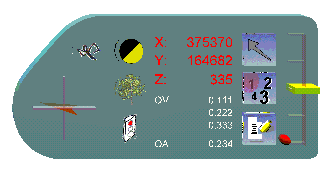
1. Compass The orange coloured arrow shows the direction of the North. It is a powerful navigational clue compensating to a small extend for the lack of the clues found in nature necessary when wandering around an area (wind and its direction, light, sun, sounds etc...).
2. Fly/Walk Toggles between fly navigation mode (quite useful if you are unfamiliar with the city) and walk mode. Default value is FLY.
WARNING: once you switch to walking, switching back to flying drops you to elevation 0 - which is at least 25 metres below the ground (still trying to figure out why...) Just use the arrow keys to move up, or simply choose another one of the predefined cameras to correct your navigation height.
3. Day/Night Toggles a pseudo night simulation mode by switching off the main light. Default value is DAY.
4. Summer/Winter Toggles between a summer version of the trees with full foliage and a winter version with just the trunks. Defaults to SUMMER. Since foliage can distort views from particular parts of the city, it is quite important to be able to visualise the city both in both summer and winter.
5. Viewer Position Reports the X,Y and Z coordinates of the viewer. Bearing in mind that the whole application focus is engineering, the XY is in plan and Z denotes the height (using the CAD and not the VR notation). In this particular example it reports metres from the UK Ordnance Survey starting point (at the southwest tip of the island in Cornwall - hence the 6 digit numbers in plan).
Moving the cursor over the landscape will report on the bottom of the browser window the coordinates of the current cursor position, whereas placing the cursor over a building will report its address.
6. Editing Modes In this demo, three main modes of editing are configured.
- Editing and testing alternatives in the Empire hotel (go to the Empire Hotel view before toggling button 7)
- Flying the balloon at the west end of the city (use the scroll bar!)
- Adding and deleting trees (just click on the landscape to add trees, click again on the trunk of an inserted tree in order to delete it)
every new project added/investigated within the city model, adds a new editing option.
7. Editing Options Within each mode, there may be different options to toggle through.
8. Scroll-Bar Used in different editing modes to scale buildings, translate the balloon flying over the city, etc.
9. Scroll-Bar Reset Sets the scale or translation editing factor back to the default value.
10. Report Saves all editing on the current session to a file on the server. This file can be decoded and used to assess and document the session (not implemented yet).
11. Viewer's Direction Used internally to define perspective camera locations that can be then exported back to CAD packages in order to create plot files or high quality renderings from the exact location.
12. TourBus Animation Toggles the Bath tourbus animation.Takes you a small tour of the city centre using a double-decker bus. Recommended for new visitors - just switch to the Tour Bus camera and start the bus moving.
Browser Compatibility
2025 Update, The VRML model currently only works in this embedded X-ite code
Enjoy your visit to Bath and please let me know of any comments you may have.